


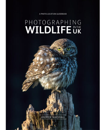
Description
Featuring
- 150 locations including all the classics
- 750 photographs
- Detailed maps, directions and co-ordinates for each location
- Best seasons and time of day to visit Sun compass
- Accommodation and best pubs
- Roadside and short walk locations
- Longer photographic walks
- Accessibility information
Maps
OS style maps produced by Don Williams of Bute Cartographics are used throughout, along with lat-long co-ordinates, map co-ordinates and postal codes for each location. Access information includes whether a location is accessible by wheelchair.
Contents
Highlights include:
- Ladybower & the Derwent Reservoirs
- Bamford Weir
- Stanage Edge
- Hathersage
- Surprise View & Padley Gorge
- Froggatt Edge & the Eastern Edges
- Dove Stones
- Chatsworth House & Haddon Hall
- Tideswell & Litton
- Peter’s Stone & Cressbrook Dale
- Monsal Dale & Ashford-in-the-Water
- Bakewell
- Hartington
- Lathkill Dale
- Dove Dale
- Vale of Edale
- Winnats Pass
- Mam Tor
- Cave Dale and Peveril Castle
- Kinder Downfall
- Three Shire Heads
- Lud’s Church
- Parkhouse & Chrome Hills
- The Roaches
- High Tor & Matlock Bath
- Peak Rail
- Black Rocks of Cromford
- Derwent Valley Mills – A Heritage Tour
- Well Dressing & Agricultural Shows Listings
Peter Gates (verified owner) –
This is such a wonderful and different book it is difficult to adequately describe it. I bought it from Fotovue and I am astonished at the quality of the photographs and the text.
I am a regular walker in the Peak District and have been to many of the locations in the book. It is the sort of book I’ve been waiting for. Not only does it have a great deal of information on where to go and how to get there, it has details info in locations, lighting, composition etc. I dont know how you did it. Wonderful!!
Tracey Boylan –
I am a relatively inexperienced amateur photographer and this book was a gift from a friend who recommended it highly as a professional photographer himself.
Firstly it is a very detailed work that is dense with information (and great photographs).
It is very well organised, dividing the Peak District by geographical areas and then offering advice on shooting locations, viewpoints and what to photograph. There are clear maps for all the locations and great tips about things such as parking (they even provide postcodes for this) accessibility and the best times of the day/year to shoot. It’s so clear and practical whilst offering a wonderful level of detail. There are useful charts detailing sun elevation and positioning throughout the year. There’s also stuff on roads, public transport and places to stay. There is a useful section about weather and even a fascinating description of different types of fog, which should appeal to the inner geek in everyone!
Secondly, this book has clearly been a work of great dedication. It’s abundantly clear that the authors live and work in the Peak District and that they know it intimately. The love of the landscape jumps off the page in the photographs and you feel that you are becoming a party to genuine ‘insider knowledge’ such as where you might encounter friendly donkeys or find little places to leave your car.
Thirdly, the photography. It’s amazing and truly one of the most accomplished collections I have seen. The understanding of light is what makes the work very special. Places that I have known for years are captured with such starkness and beauty… well. It made me realise that I have an awful lot to learn about taking photographs!
Finally, This book is written in such a straightforward non-patronising style that the reader feels truly enabled and more confident about what they are doing with their camera.
I am delighted with this find and am 100% certain it will become a photography classic. I know what I’m buying my friends for Christmas now!
Ian Prescott –
This book is an outstanding piece of work by two people who know The Peak District, photograph it and want to share that knowledge and experience so that others can derive the same pleasure that they have had.
Everything about this book is close to perfection. Detailed information about locations, directions and crucially, for a disabled amateur phitogropher like myself, accessibility details. The photography is inspirational and instructional; the format of the book means it can be carried on visits reasonably easily; the print quality and and image reproduction is superb. It’s more than just a guide to to where and how but also best times to visit the various and varied areas of the park are covered in detail. The section on events and shows is also a really useful addition as are the sun compass and sunset/sunrise times.
I am already panning my first trip for when my Motability car is delivered and I am ready to explore places I have only ever visited in a brief, cursory manner before.
I shall certainly be purchasing other guides in this series and if they are only half as good as this one they will still be superb.
All the in all a wonderful book. Genuinely 5 star quality.
chris –
What an excellent book, I’m sure I will add others from the series too. Great work.